Nice to meet you, Ryu!
This article translates my article with Google Translate Some parts have different meanings, but please refer to them.
This time I will write an article about Hokkaido where I live. My town is a mountainous area surrounded by mountains! Recently, I would like to write an article about foreigners coming from overseas who would like to teach me the route to this mountain.
It may be difficult to climb, but the view from the top is the best! In winter, many people wear skis and climb up and down. I tried to find out the best mountain views in Hokkaido.
In Japanese
![]()
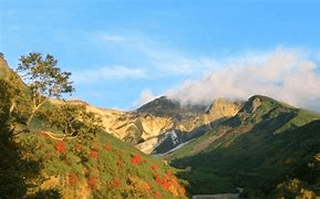
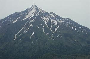
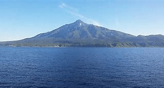
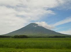
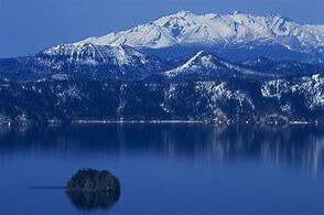
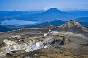
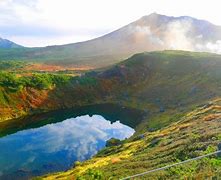
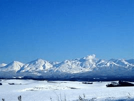
Mount Rishiri
Mt. Rishiri, the symbol of the island, is the northernmost land in Japan! It has been selected as one of Japan’s 100 Famous Mountains and has become a very beautiful mountain, but there are some dangerous spots where erosion along the mountain trail is dangerous, but the scenery after climbing is spectacular.
place
Place: Rishiri Town, Fuji Town, Hokkaido
Altitude: 1718.7m
Climbing, downhill time: About 9 hours (depending on the person)
Means of transportation
The nearest airport is Wakkanai Airport. Take a bus from the airport to Wakkanai Port. Take the ferry to Rishiri Island! It takes about 10 minutes by taxi from the port to the Rishiri Kita-Kano Campus where the trailhead is located.
![]()
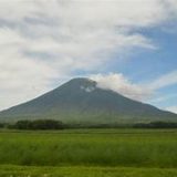
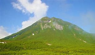
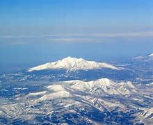
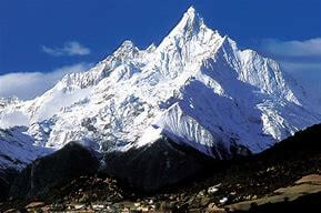
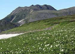
Mount Yotei
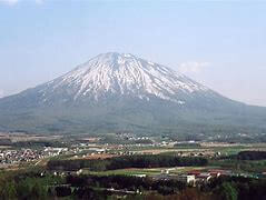
Start from the Yotei climbing mouth! The scenery is good even when you are walking, and you can see many alpine plants. Even beginners can climb.
place
Place: Niseko Town, Hokkaido
Altitude: 1898m
Climbing, descending time: about 5 hours (depending on the person)
Means of transportation
Automobile
: From Sapporo, Route 250 (Nakayama Pass), 1 and a half to 2 hours
: From Chitose, take Route 16 and Route 276 (via Bifuka Pass) for about 1.5 hours!
: A 5-minute drive from Makkari city. It takes about 5 minutes from the parking lot to reach the trail.
Public institution
: From Sapporo, take the bus bound for Toya and get off at Rusutsu, then take the bus bound for Tamachian and get off at Yotei Nature Park Iriguchi.
: From Chitose, take the Chuo Bus bound for Niseko (for a limited time), get off at Rusutsu Resort Hotel Mae, transfer to the Donan Bus bound for Hachian, and get off at Yotei Nature Park Iriguchi.
: From JR Taichi-an Station, take the Donan Bus bound for Rusutsu and get off at “Yotei Nature Park Entrance”.
*Approximately 20 minutes walk from there to the trailhead
![]()
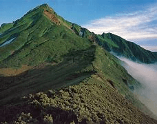
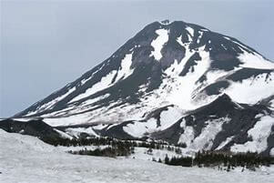
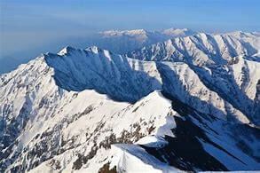
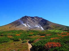
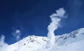
Mt. Rausu
It is the highest mountain in the Shiretoko Federation, with its beautiful deep forest, which is so unique to Hokkaido. At the top of the mountain, a lava dome rises and you can also see the appearance of strange rocks. Its appearance is magnificent and spectacular.
place
Place: Shari Town, Hokkaido, Rausu
Altitude: 1660m
Mountaineering: 9 hours downhill (depending on the person)
Means of transportation
Automobile
: From Memanbetsu Airport (via Neboku Pass) About 2 hours 40 minutes
: About 2 hours from JR Abashiri (via Neboku Pass)
: About 1 hour 40 minutes from JR Shari Station (via Neboku Pass)
: About 40 minutes from Utoro (via Shiretoko Pass)
: About 70 minutes from Nakashibetsu Airport
: About 3 hours from Kushiro Airport
: About 3 hours 10 minutes from JR Kushiro Station
Transportation facilities
: There are 3 airports in Eastern Hokkaido, Memanbetsu Airport, Nemuro Nakashibetsu Airport, and Tancho Kushiro Airport.
: JR (closest station, Shiretoko Shari station), Akan bus
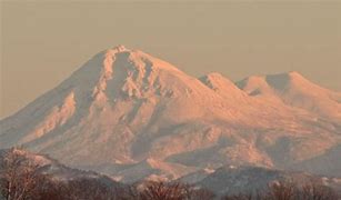
Mount Shari
Mount Shari is located at the base of the Shiretoko Peninsula and is one of Japan’s 100 Famous Mountains. You can enjoy from beginners to advanced users. There are three mountaineering courses, and some courses can be enjoyed by families.
From the top of Mt. Shari, you can enjoy a great view of Mt. Rausu, Shiretoko Federation, Lake Mashu, Lake Kussharo, Sea of Okhotsk and the Daisetsu Federation.
place
Location: Fuji, Shari-cho, Shari-gun, Hokkaido
Altitude: 1547m
Mountaineering: ① Kiyosato Course: ② Kitahoritsu (Mitsui) Course: ③ Neboku Course. About 7 hours 20 minutes
Means of transportation
From nearby airport to Kiyosato
Memanbetsu Airport
: About 50 minutes by car
: JR Abashiri Station JR Kiyosato Station (about 60 minutes)
Nakashibetsu Airport
: About 60 minutes by car
Kushiro Tancho Airport
: About 120 minutes by car
: Kushiro Airport JR Kushiro Station (about 150 minutes)
: JR Kushiro Station JR Kiyosatocho Station approximately 130 minutes
Mt. Akan
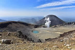
There are two types of Mt. Akan, Mt. Oakan and Mt. Meakan. Even beginners can easily climb and there are hot springs in the vicinity. You can enjoy the crater that you can see from around the top of Mt. Akan. Because it is an active volcano, you can check volcanic activity as well as weather forecast, so you can safely climb with your family.
place
Place: Kushiro City, Hokkaido
Altitude: About 1499m
Climbing: about 4 hours (depending on the person)
Means of transportation
: By car, go north on Route 240 at both Kushiro Station and Kushiro Airport, and after passing Akan Lake, turn left. It will be the parking lot on the shore of Lake Akan. Time is about 1 hour 40 minutes
Kushiro Airport, Kushiro Station (Akan Bus) Lake Akan Onsen (Taxi) Meakandake Onsen Trailhead, Onneto National Camp, Lake Akan Trailhead
Daisetsuzan
Daisetsuzan is located in central Hokkaido. Daisetsuzan is the highest peak in Hokkaido, Mt. Asahidake, to the south are the vast plateaus of Takanegahara, Nakabetsu and Mt. Tomuraushi, and to the southwest is the Tokachi Federation.
place
Place: Higashikawa-cho, Kamikawa-gun, Hokkaido (Mt. Asahidake)
Altitude: 2291m (Mt. Asahidake)
Mountaineering: There are two ways to ride the ropeway, but you can reach the summit in about 5 hours each way without riding.
Means of transportation
By car: Asahikawa Airport Doo Expressway Asahikawa Kita IC Asahikawa Monbetsu Expressway Kamikawa Sounkyo IC Route 849 National Route 39 National Route 273 Route 1162 Akadake Ginsendai Mountain Trail, 2 hours 30 minutes from Asahikawa City
Tomuraushi Mountain
Daisetsuzan is also known as the roof of Hokkaido, where vast mountains spread out. Tomuraushi mountain is in the south of the Daisetsu Mountains. Spectacular views of the Daisetsu Mountains, beautiful lakes and flower gardens, the natural beauty of rocks and Japanese pine trees, also called Japanese gardens. It is a recommended mountain.
place
Place: Kamikawa General Promotion Bureau Kamikawa-gun Biei-cho, Tokachi General Promotion Bureau Kamikawa-gun Shintoku-cho
Altitude: 2141m
Mountaineering: about 10 hours (depending on the person)
Means of transportation
About 220km from Sapporo: About 3 hours and 30 minutes via Hokkaido Expressway Expressway Tokachi Tokachi Shimizu IC National Route 274
Approx. 171km from Asahikawa: Approx. 121km from Furano: National Route 237 Furano National Route 38 Town Road Kamisahoro Route 17 Approx. 3 hours 15 minutes
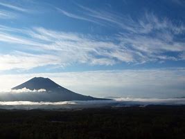
Tokachidake
Tokachidake is an active volcano located in the center of the Tokachi Federation. You can see the cityscape of Biei and it is a popular spot for locals.
place
Place: Biei Town, Kamikawa District, Hokkaido
Altitude: 2077m
Mountaineering: Approximately 7 hours round trip (depending on the person)
Means of transportation
A car is convenient for going to Tokachidake. About 3 hours from Sapporo.
For transportation, get off at JR Furano Line Biei Station! Take the Dohoku Bus “Biei Shirokane Line” “Shiragin Onsen” or “Protection Center Mae” and get off at there for about an hour and a half and a distance of about 5km.
Summary!
This time, I introduced the mountains of Hokkaido roughly. From now on, I would like to make articles carefully one by one. Every mountain is wonderful, so why not try climbing it when you come to Hokkaido!
In Japanese